Choquequirao Trek 4 Days: Deeper Into the Last Refuge of the Incas
There’s a reason Choquequirao gets called “the lost city of the Incas.” When Spanish forces closed in during the conquest, this citadel became one of the final strongholds of Inca resistance — tucked so deep in the Vilcabamba Valley, in the province of La Convención, that it stayed hidden from the outside world for centuries afterward.
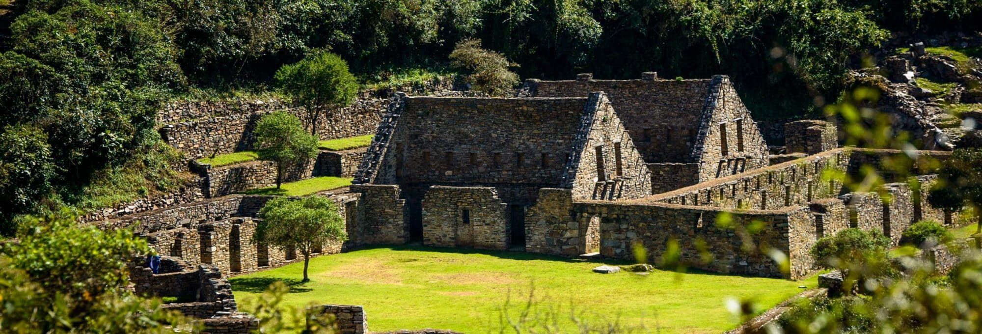
What survives today rivals Machu Picchu in scale and craftsmanship. Terraces, temples, and stone plazas climb the mountainside, and archaeologists estimate only a third of the site has been uncovered so far — which says a lot about how much history is still waiting under the vegetation.
Getting there is part of the adventure. From Cusco, it’s roughly 145 km by paved road to Cachora, followed by a 10 km stretch of dirt road into the village itself. From Cachora, the trail continues for about 32 km, winding through valleys and ravines and skirting the edge of the Apurimac Canyon — often cited as the deepest canyon on the planet — before finally reaching Choquequirao, the “Cradle of Gold.”
Duration
4 days
Tour type
Trekking
Difficulty
Challenging
Guide
Inglés, español
Group size
6 to 10
Maximum altitude
3700 masl
Itinerary
Day: 01 Cusco – Cachora – Chiquisca – Santa Rosa Alta
We collect you from your hotel around 3:00 am for the private transfer from Cusco to Cachora (2,850 masl), where there’s time for a local breakfast (not included, but inexpensive and worth trying) before meeting the rest of the support team — cooks and muleteers — and setting off on the day’s main hike.
The trail climbs through shifting microclimates for the next 6 to 7 hours, with the snow-capped Padreyoc visible in the distance and the surrounding flora and fauna changing with the altitude. From the Capuliyoc viewpoint, one of the trek’s signature moments comes into view: the Apurimac Canyon, one of the deepest on the planet, with the river far below.
From here, the descent continues past Cocamasana — one of the best canyon viewpoints on the entire route — down to Chiquisca, where lunch is served with the first distant views of Choquequirao and a preview of the trail ahead. The final stretch drops to Playa Rosalina (1,550 masl), crosses the Apurimac River by suspension bridge, and climbs to the night’s camp at Santa Rosa Alta, where tea and dinner close out a long first day.
Meals: Lunch, afternoon tea, dinner
Distance: 15 km / 9.3 mi
Walking time: 6–7 hours
Camp: Santa Rosa Alta
Max altitude: 2,890 masl / 9,482 ft
Day: 02 Santa Rosa Alta – Marampata – Choquequirao Archaeological Site
After breakfast, a demanding 3.5-hour climb leads to camp at Marampata (2,918 masl). From there, a shorter ascent brings us to the entrance of the Choquequirao Archaeological Complex, with the Apurimac Canyon and surrounding peaks providing a dramatic backdrop for the final approach.
Often described as the “sister city” of Machu Picchu, Choquequirao shares more than a passing resemblance — both citadels sit at similar latitudes, both span more than 8 hectares, and both overlook deep river canyons. The difference is scale: archaeologists estimate that only about one-third of Choquequirao has been excavated, with new discoveries still being made.
The guided visit covers three main areas: the principal plaza at the heart of the citadel, the “Llamas Sector” — home to some of the site’s finest terraces, decorated with white-stone llama iconography — and the “Ushnu Sector,” the ceremonial viewpoint that produces Choquequirao’s most iconic photograph. After the tour, we return to camp for tea and dinner, resting up before retracing our steps the following day.
Meals: Breakfast, lunch, afternoon tea, dinner
Distance: 10 km / 6.2 mi
Walking time: 6–7 hours
Camp: Marampata
Max altitude: Choquequirao Citadel, 3,050 masl / 10,006 ft
We’re back on the trail by 6:00 am, retracing the previous days’ route toward Chiquisca. The first stretch is a roughly 5-hour descent back through Playa Rosalina, crossing the same suspension bridge over the Apurimac before a short break.
From there, an uphill push of about 1.5 hours brings us to Chiquisca for lunch. After resting, a final 1-hour walk leads to camp at Cocamasana, where the evening winds down with tea and dinner under the canyon sky.
Given how hot this stretch of canyon can get, we start early, before the sun is fully up. After breakfast, roughly 3 hours of steady climbing takes us away from the canyon’s heat and toward Capuliyoc pass (2,885 masl), the trek’s final high point, with one last look back at Choquequirao and the surrounding peaks — including the snow-capped Padreyoc — before descending to meet our transport back to Cusco.
Optional: time and group energy permitting, we can stop at the Conoc hot springs on the way back — a welcome way to unwind before returning to the city.
Meals: Breakfast, snacks, lunch
Distance: 5 km / 3.1 mi
Walking time: ~3 hours
Max altitude: Capuliyoc, 2,885 masl / 9,465 ft
Choquequirao Trek 4 Days: Route Overview
The adventure begins with an early private transfer from Cusco to San Pedro de Cachora, following the main Cusco–Abancay highway before turning off at Ramal onto a 16 km dirt road that winds through open Andean scenery down to the village itself.
Cachora sits at 2,903 masl, with the snow-capped peak of Padreyoc visible in the distance. From here, the trail drops through a striking range of ecosystems — Andean farmland giving way to a hot, arid canyon lined with cactus and agave, then climbing again into cloud forest beneath the Vilcabamba mountain range.
Past Chiquisca, the trail plunges to the floor of the Apurimac Canyon, reaching Playa Rosalina at 1,550 masl — 19 km from Cachora — where a suspension bridge crosses the river and the climb toward Choquequirao begins in earnest.
What sets the 4-day itinerary apart from the shorter route is the extra night at Sunchupata, a quieter camp closer to the citadel that gives trekkers a full, unhurried day to explore Choquequirao — rather than rushing the visit into a single afternoon. Along the way to Sunchupata, the trail passes through Santa Rosa, known for its “cambrai,” a traditional sugar-cane drink, before continuing on to Marampata and beyond.
Choquequirao Trek 4 Days — Day-by-Day Summary
Day 1: Cusco → Cachora → Chiquisca → San Rosa Alta
Day 2: San Rosa Alta → Marampata → Choquequirao → Marampata
Day 3: Marampata → Chiquisca → Cocamasana
Day 4: Cocamasana → Capuliyoc → Cachora → Cusco
Trip Details
Activities: Hiking, trekking, and adventure travel through the Apurimac Canyon.
Difficulty level: 4 out of 5 (challenging) — a good fit for hikers with prior trekking experience or solid physical conditioning.
Distance covered: Approximately 64 km (40 miles) round trip.
Maximum altitude: 3,700 masl / 12,139 ft (highest point on the trail); the Choquequirao citadel itself sits at 3,050 masl / 10,006 ft.
Minimum altitude: 1,550 masl / 5,085 ft (Apurimac River crossing near Playa Rosalina).
Lodging: 3 nights camping, at San Rosa Alta, Marampata, and Cocamasana.
Type of tourism: Trekking, hiking, nature, and Inca archaeology.
Group size: 6 to 10 people, with a professional bilingual guide (English and Spanish).
Meals included: Breakfast, lunch, and dinner (except Day 1 breakfast and Day 4 dinner) — see full details in Inclusions.
Departure days: Daily departures available; minimum of 2 people required per group.
Best season: April to November (dry season) is recommended for optimal trail conditions.
Minimum age: Recommended for travelers aged 12 and older due to the physical demands of the route.
Start: Hotel pick-up in Cusco around 6:00 am.
End: Drop-off at your hotel in Cusco around 6:00 pm on Day 4.
Highlights
Cross the dramatic Apurimac Canyon over four unhurried days, with more time to acclimatize and take in the scenery than the shorter 3-day route.
Explore Choquequirao, a 15th-century Inca citadel considered one of the most significant Inca settlements in the Cusco region — with the extra day allowing for deeper exploration of the complex.
Camp at three distinct sites — San Rosa Alta, Marampata, and Cocamasana — each offering a different vantage point over the canyon and surrounding mountains.
Take in sweeping views of the Vilcabamba mountain range and the citadel itself from multiple angles along the trail.
Best hiked from April to November (dry season); the rest of the year, landslides can occasionally close sections of the trail.
Suitable for hikers in good physical condition — the extra day compared to the classic 3-day route makes for a steadier pace with less daily distance to cover.
Professional bilingual guide on the Choquequirao route.
Entrance ticket to Choquequirao, covering both travelers and our support team.
Private camping for 3 nights — at Santa Rosa Alta, Marampata, and Cocamasana — in four-season tents.
Waterproof, four-person tents (shared by 2 trekkers for extra comfort).
Sleeping mat per person.
Full camping equipment: dining and kitchen tents, tables, chairs, and cooking gear, all carried by our pack horses.
Duffel bag service: up to 7 kg (15 lbs) of personal luggage per person, including your sleeping bag, carried by horse.
Professional mountain chef — you won’t go hungry on this trek.
Meals: 3 breakfasts, 4 lunches, 3 dinners, including vegetarian, vegan, or other dietary options at no extra cost.
Boiled, filtered drinking water from Day 1 lunch onward.
Wake-up tea each morning and afternoon tea before dinner.
First aid kit.
Emergency medical kit and oxygen tank.
24-hour customer support throughout your trip.
Camp locations rarely change once your booking is confirmed. In rare cases — due to government regulations, weather conditions, or a group’s physical condition — adjustments may be necessary, and we’ll always notify you in advance.
No Included
Not Included
Breakfast on Day 1.
Dinner Day 4.
Sleeping bag: $ 25 USD per person.
Air mattress: $ 25 per person.
Walking poles: $ 20 USD per pair.
Personal tent: $ 30 USD (booking in Cusco).
Any items or activities not mentioned in the itinerary.
What to Bring for the Choquequirao Trek
Original passport (required for trail registration).
A warm jacket, hat, and gloves — nights at camp drop well below the daytime canyon heat.
Waterproof jacket or rain poncho.
Comfortable, quick-dry T-shirts.
Comfortable hiking pants.
A wide-brim sun hat.
Broken-in hiking boots — this is not the trek to test out new footwear.
A reusable water bottle or hydration bladder.
A headlamp with spare batteries (more practical than a handheld flashlight).
Camera.
Sleeping bag — not included in the tour price, but available to rent with us.
Health & Personal Care
Sunscreen, SPF 35 or higher recommended given the altitude and canyon sun exposure.
Insect repellent.
Personal toiletries.
Any personal medication you take regularly.
Water purification tablets or extra cash for bottled water along the way, as a backup — boiled drinking water is provided daily as part of the tour.
Optional
Trekking poles with rubber tips.
Basic blister care: tape, bandages, moleskin.
Sandals for camp, to give your feet a break in the evenings.
Extra cash for snacks, drinks, or souvenirs along the way.
Choquequirao Trek 4 Days 3 Nights — Pricing 2026
Choose between joining a small group departure or booking a private tour with a dedicated guide. This trek is guaranteed to depart with a minimum of 2 travelers.
Service Type
Group Size
Price per Person
Group Tour
Shared group (6–10 people)
$ 449.00 USD
Private Tour
2 people
$ 729.00 USD
Private Tour
3 people
$ 650.00 USD
Private Tour
4 people
$ 580.00 USD
Private Tour
5 people
$ 530.00 USD
Private Tour
6 people
$ 499.00 USD
Payment Terms
Reservation deposit: $100 USD per person to confirm your spot.
Remaining balance: paid in cash (USD or Peruvian Soles) or by card in Cusco before departure.
Card and PayPal payments carry a 5% processing fee charged by the payment gateway, not by Aremika Expeditions.
Price Guarantee
Once your booking is confirmed, your price is locked in and will not change, regardless of currency fluctuations or seasonal demand.
Private tours include a dedicated bilingual guide and flexible departure times. All prices include the services listed in the “What’s Included” section above.
Why Choose Aremika Expeditions for the Choquequirao Trek 4 Days 3 Nights?
Trusted by over 999 travelers on TripAdvisor.
Steadier Pace: Shorter daily distances, more time at Choquequirao.
Pace, mostly. The 3-day version packs the same canyon crossing into fewer hours, which some hikers prefer if they’re short on time. The extra day here spreads the walking out — shorter daily distances, an additional camp at Santa Rosa Alta on the way in, and a more relaxed rhythm overall. If your legs (or your schedule) can handle a compressed itinerary, 3 days works. If you’d rather not feel rushed, this is the better fit.
Do I need to bring my own tent?
No. Waterproof four-season tents, sleeping mats, and the full camp setup — dining tent, kitchen, tables, chairs — are all included and carried by our pack horses. The only thing not included is a sleeping bag, which you’re welcome to bring or rent from us before departure.
What happens if I can’t keep up or get sick during the trek?
Our guides carry a first aid kit and an oxygen tank on every departure, and we’re in radio or phone contact with our Cusco office throughout the route. If someone needs to turn back or slow down, we adjust the plan around them rather than the other way around — this isn’t a race, and no guide is going to push a struggling hiker to keep pace with the group.
Is this trek okay for someone with no camping experience?
It’s more about fitness than camping skills. You won’t need to pitch your own tent or cook — our team handles that — so the real question is whether you can walk 5 to 7 hours a day on uneven terrain. If you’ve never slept outdoors before, the biggest adjustment is usually the cold nights and early mornings, not the logistics.
What’s the food actually like on a multi-day trek?
Better than most people expect from a campsite. We bring a professional mountain chef who prepares full meals — not just instant noodles — including vegetarian, vegan, or other dietary needs at no extra charge. Breakfasts tend to be hearty, lunches are substantial enough to fuel the afternoon walk, and there’s always tea waiting when you roll into camp.
Can I rent trekking poles or a sleeping bag instead of bringing my own?
Yes, both are available to rent through us ahead of your departure. It’s usually the easier option for travelers who flew in without bulky gear or don’t want to check an extra bag just for a multi-day hike.
How much does the temperature change between day and night?
Quite a bit. Down in the canyon near Playa Rosalina, midday heat can feel almost tropical, while camps like Santa Rosa Alta and Marampata cool off sharply after sunset — it’s not unusual to go from a T-shirt at 2pm to a warm jacket by 7pm. Layering is less about comfort and more about necessity on this route.
How should I train before attempting this trek?
Focus on stamina over strength. Long walks, stair climbing, or hiking with a loaded daypack in the weeks beforehand will do more for you than gym workouts. If you live somewhere with hills or elevation, use them — the descents are just as demanding on your knees as the climbs are on your lungs.
Can I book this as a private tour instead of joining a group?
Yes. Private departures are available for groups of 2 or more, with the same guide, meals, and camping setup as the group tour, just with more flexibility on pace and start times. Group departures run daily with a minimum of 2 travelers, so private booking mostly comes down to preferring your own schedule over a shared one.
Is drinking water provided, or should I buy my own?
We provide boiled, filtered water daily starting from lunch on Day 1, so a reusable bottle is really all you need to bring. Some travelers still carry purification tablets or a bit of extra cash as a backup, but it’s not something you need to rely on.
Reviews
Reviews from our travelers
Over +999 verified reviews on TripAdvisor
Price From: $ 449.00
Leave your details
Travel with Plan your trip to Peru!
Chat with a local specialist who can help you organize your trip.



 Duration
 Tour type
 Difficulty
 Guide
Guide Group size
 Maximum altitude